 Cart - 0
13
November
1-79 : Burnside South
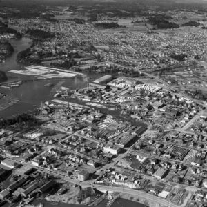
This is the Burnside area of Victoria, looking north-west, from 1951. You get a great view of the sawmills and housing in Burnside and you can practically see all the way up to the west side of Saanich.
[Total: 8 Average: 3.8/5]
Purchase Options
1-79 (Digital Download)From $25.00
1-79 (Paper Print)From $30.00
Great view of the CNR’s Selkirk Trestle and BCFP’s big mill. Also, fascinating to see the CNR’s Colquitz Trestle without the highway beside it.
I am old enough to remember the area and it is on Gorge Rd where Selkirk now is.
The bridge is not the Galloping Goose bridge and the road on the right is rock bay
just found the family home on Albion street, great info
Most fascinating to me is all the trees that are still in Gorge Park!
If you scroll to the very top right, you can see interurban road and CN’s Colquitz bridge and where the highway will eventually go. Also, where Tillicum rd is now, the steep road grade doesnt exist back then, all level with no hill. Deadman’s island is still covered in all trees. ( Christie Point Appts now)
This is not Burnside area but the mill that was off Gorge Road west. Burnside was never near the water
Does anyone know what that ” Maze ” affair between David and John ST. is on the lower right of the picture . I’m thinking it may be some sort of a storage yard for the Dalziel Box Factory. All my Relations are gone now so I cant get an answer there.
It appears the Tillicum Drive-in is just being built on Admirals. Thanks for posting!