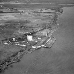
BO-48-3590 : Massey Tunnel Site
There is a bit of uncertainty with the exact location of this image, but it appears to be roughly the location of the George Massey Tunnel from November 22, 1948. It looks like the tunnel will end up going through the field in the lower-left corner of the image. Construction of the tunnel didn’t begin until 1957 and at that time it was known as the Deas Island Tunnel.
Thanks to Bernard, we now know the main buildings in the photo are part of Canada Rice Mill.
 Cart - 0


Just beyond the mill, there appears to have been a recent breach in the dike, and a setback dike further inland to contain the water. This must have been after the Flood of 1948. This land has since been filled in, and is part of the Fraser Wharves auto terminal.
Dyan, you must have known the Focker Family. they lived in one of the houses too. Scott Minler also worked there.
I was so happy to see the Mill, it brought back so many memories. My Dad worked there for over thirty years. I have his retirement watch, he was so proud of it.
The long building on the far left was torn down, they built a new building there with a loading dock so trucks and the train could load hops, dates, raisins, coconut and rice.
Your B)-48-3590 Massey Tunnel site, information may be a bit off.
I believe the indentation of water just to the east of the Rice Mill site is the current BC Ferries yard. This photo shows a road going through the middle of the watercourse, which has been removed.
All of the trees showing a river or stream complete the accuracy of above.
I think you are generally right. I think we can see 5 road running northwards and then the intersection with the Steveston Highway. I think I remember that bard in the top left as being to the west of the freeway in the late 1960s.
I am fairly certain that is the Canada Rice Mill you are looking at.
http://www.richmond.ca/cityhall/archives/search/datasearch/images/1984-0006-00005.jpg
http://www.richmond.ca/cityhall/archives/search/datasearch/images/1983-0006-00082.gif