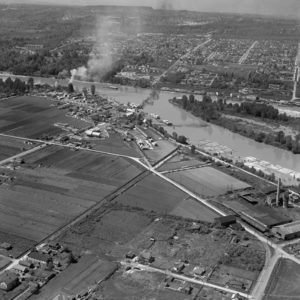
BO-50-109 : Queensborough
This is the Queensborough area of New Westminster from 1950. To help you get your bearings, the photo was taken from the Queensborough side looking North-West back towards New Westminster. Ten years after this photo, the saw mills were replaced by the Queensborough Bridge.
 Cart - 0


I turned 16 in 1960 and my dad got me a job at Pacific Pine. On Saturdays I was on the clean-up crew in the sawmill and Sundays I worked cleaning out the ashes from the Beehive burner which is where the smoke is coming from. The Queensborough Bridge DID NOT replace the Sawmill. I worked at the Sawmill for 6years and left in July 1965. The Queensborough Bridge would be just left of the stand of trees in the top left side of the picture. The Bridge would be parallel to Wood Street which is not in the picture. I lived on Wood St and looked at the bridge’s toll Booths.
Yes, that is 20th Street above the black plume of smoke. I can see our old family home with the double peaked roof on the corner of 7th Avenue and 20th St and an undeveloped area that became Grimston Park between 7th Avenue and the train tracks below. In the late 60’s there was still a beehive burner across the river that you could see looking down 20th St from the New Westminster side.
I grew up on 337 Ewen Ave, the house on the far bottom left. It’s still standing today (parallel house to west of it burnt down years ago).
I’m not sure, if you follow the Google Earth link, it looks to me like the black plume of smoke is closer to 22nd Ave.
Wouldn’t the Queensboro Bridge be near where that white plume of smoke is coming from? The buildings there would now be the ICBC yard and the Queensborough Landing shopping center.
Above the black plume of smoke looks like 20th.