 Cart - 0
14
November
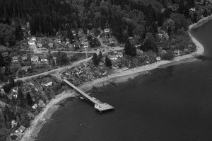
BO-48-2918 : Granthams Landing
This is a close up of Granthams Landing, just north of Gibsons, from 1948.
This image was originally mislabelled as Hopkins Landing. Thanks to Margo for pointing out the error.
Click to rate this post!
[Total: 3 Average: 3.7]
Purchase Options
BO-48-2918 (Digital Download)From $25.00
BO-48-2918 (Paper Print)From $30.00
This is GRANTHAMS Landing – the dark flush in the ocean (salt water sea) to the right is a creek mouth – and I will have to ask around about what appears to be a water wheel in the creek – at the time there was a wooden bridge over that creek along “Marine Drive” – you cannot tell now as there is no wood bridge – but a careful person would note the filled ravine along Marine Drive. to the north (right hand side) in this photo – that was a post office and store. Mrs Fisher lived to the south of the wharf. Union Steamships used those wharves all along the coast. (Anytime the place is called LANDING) Thank you.